Distribution of the Earth’s water
Earth is known as the “Blue Planet” because 71 percent of the Earth’s surface is covered with water. Water also exists below land surface and as water vapor in the air. Water is a finite source. The bottled water that is consumed today might possibly be the same water that once trickled down the back of a wooly mammoth. The Earth is a closed system, meaning that very little matter, including water, ever leaves or enters the atmosphere; the water that was here billions of years ago is still here now. But, the Earth cleans and replenishes the water supply through the hydrologic cycle.
The earth has an abundance of water, but unfortunately, only a small percentage (about 0.3 percent), is even usable by humans. The other 99.7 percent is in the oceans, soils, icecaps, and floating in the atmosphere. Still, much of the 0.3 percent that is useable is unattainable. Most of the water used by humans comes from rivers. The visible bodies of water are referred to as surface water. The majority of fresh water is actually found underground as soil moisture and in aquifers. Groundwater can feed the streams, which is why a river can keep flowing even when there has been no precipitation. Humans can use both ground and surface water.
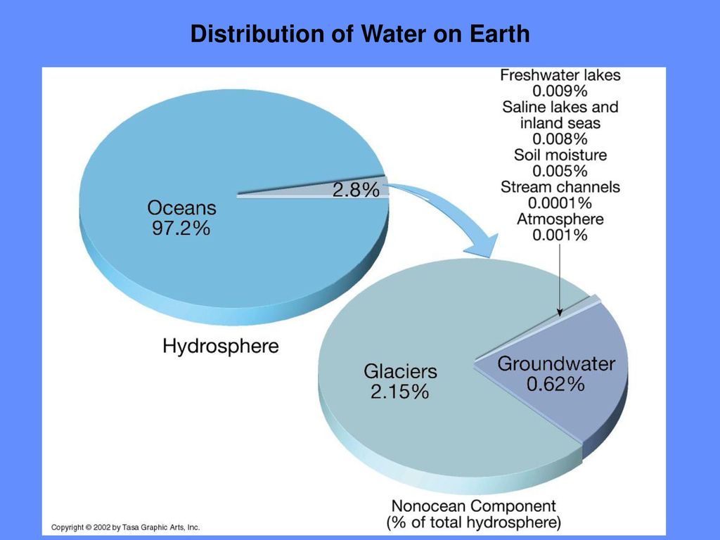
Distribution of the water on Earth
- Ocean water: 97.2 percent
- Glaciers and other ice: 2.15 percent
- Groundwater,: 0.61 percent
- Fresh water lakes: 0.009 percent
- Inland seas: 0.008 percent
- Soil Moisture: 0.005 percent
- Atmosphere: 0.001 percent
- Rivers: 0.0001 percent.
Surface water is far easier to reach, so this becomes the most common source of potable water. About 321 billion gallons per day of surface water is used by humans. About 77 billion gallons of groundwater are used each day. Problems also exist in contamination of the water supplies. This further limits the amount of water available for human consumption. Water is found in many different forms and in many different places. While the amounts of water that exist seem to be plentiful, the availability of the water for human consumption is limited.
Surface waters
Surface waters can be simply described as the water that is on the surface of the Earth. This includes the oceans, rivers and streams, lakes, and reservoirs. Surface waters are very important. They constitute approximately 80 percent of the water used on a daily basis. In 1990, the United States alone used approximately 327,000 billion gallons of surface water a day. Surface waters make up the majority of the water used for public supply and irrigation. It plays less of a role in mining and livestock industries. Oceans, which are the largest source of surface water, comprise approximately 97 percent of the Earth’s surface water. However, since the oceans have high salinity, the water is not useful as drinking water. Efforts have been made to remove the salt from the water (desalination), but this is a very costly endeavor. Salt water is used in the mining process, in industry, and in power generation. The oceans also play a vital role in the hydrologic cycle, in regulating the global climate, and in providing habitats for thousands of marine species.
Rivers and streams constitute the flowing surface waters. The force of gravity naturally draws water from a higher altitude to a lower altitude. Rivers obtain their water from two sources: groundwater, and runoff. Rivers can obtain their water from the ground if they cut into the water table, the area in which the ground is saturated with water. This is known as base flow to the stream. Runoff flows downhill, first as small creeks, then gradually merging with other creeks and streams, increasing in size until a river has formed. These small creeks, or tributaries, where the river begins are known as the headwaters. Springs from confined aquifers also can contribute to rivers.
A river will eventually flow into an ocean. A river’s length can be difficult to determine, especially if it has numerous tributaries. The USGS Web site defines a river’s length as “the distance to the outflow point from the original headwaters where the name defines the complete length.” In order for water to flow, there must be land upgradient of the river, that is land that is at a higher elevation than the river. The land that is upgradient of any point on the river is known as the drainage basin or watershed. Ridges of higher land, such as the Continental Divide, separate two drainage basins. Flowing water is extremely powerful and plays an important role in creating the landscape and in humans’ lives. Flowing water is used for numerous reasons including irrigation and hydroelectric power production. Rivers erode the landscape and change the topography of the Earth by carving canyons and transporting soil and sediment to create fertile plains. Rivers carry soil and sediment that have been washed into the river when it rains or snow melts. The faster the water moves, the larger the particle size the river is capable of carrying. The USGS measures how much sediment a river carries by measuring the streamflow, or the amount of water flowing past a given site; and the sediment concentration. Sediment in the river can be helpful and harmful. Sediment, when deposited on the banks and in the flood plain, makes excellent farmlands. However, sediment can harm and even destroy dams, reservoirs and the life in the stream. Also, during floods, these sediments can be left behind as sticky, smelly mud in unwanted places.
Measuring the streamflow is accomplished by determining the stream stage and the stream discharge. The stream stage, or datum, is the height of the water surface, in feet, above an arbitrary reference point. The stream discharge is a measurement of the amount of water that is flowing at a particular point in time. It is measured in cubic feet per second. A discharge measurement determines the amount of water that is flowing in the river at any given stream stage. In order to make this measurement, the width of the river, and the water’s depth and velocity at various points must be measured at several different stream stages. A cross-section of the river is divided into intervals and the area of each interval is calculated. If the velocity was measured at different depths on the same vertical interval, then the velocity is averaged. To determine the discharge for the interval, the area is multiplied by the velocity. To find the entire stream’s discharge, an average of all the intervals’ discharges is calculated. It is important to take discharge measurements of the stream at various stream stages, even flood stage.
A river reaches flood stage when the river overflows its banks. The flood stage can be determined by measuring the gage height, or simply the height of the water in the stream measured from the river’s bottom. The streamflow can increase exponentially as the gage height increases. Thus, a small increase in gage height may indicate that a river has reached its flood stage. Floods are a fairly common, yet dangerous, natural disaster.
They normally occur because a storm or rapid snow melt has produced more runoff than a stream can carry. Dams failing, landslides blocking stream channels, and high tides are some other causes of flooding. Weather patterns can greatly influence when and where flooding will occur. By studying these patterns, geologists can determine the susceptibility of a region to having a flood at certain times of the year. The recurrence interval, measured in years, describes the magnitude of a flood. Changes in the drainage basin, such as harvesting timber or housing developments, can change the magnitude of a flood. The normally dry land that becomes covered with water during a flood is known as the flood plain. Restrictions on land use in flood plains is regulated by flood-plain zoning. Dams and levees have been built to help reduce damage caused by floods.
When flowing water travels to an area of land that is completely surrounded by higher land, a lake is formed. The water is not trapped in this low area, the water just escapes at a slower rate than the rate of incoming water. Lakes can vary greatly in area, depth, and water type. Most lakes are fresh water, however some, such as the Great Salt Lake and the Dead Sea, are salt water. Contrary to common belief, a reservoir is not the same as a lake. A reservoir is a manmade lake caused by a river being dammed. The water in a reservoir is very slow moving compared to the river. Therefore, the majority of the sediments that the river was carrying settle to the bottom of the reservoir. A reservoir will eventually fill up with sediment and mud and become unusable.
The water cycle
The hydrologic cycle or water cycle is a graphic representation of how water is recycled through the environment. Water molecules remain constant, though they may change between solid, liquid, and gas forms. Drops of water in the ocean evaporate, which is the process of liquid water becoming water vapor. Evaporation can occur from water surfaces, land surfaces, and snow fields into the air as water vapor. Moisture in the air can condensate, which is the process of water vapor in the air turning into liquid water. Water drops on the outside of a cold glass of water are condensed water. Condensation is the opposite process of evaporation. Water vapor condenses on tiny particles of dust, smoke, and salt crystals to become part of a cloud. After a while, the water droplets combine with other droplets and fall to Earth in the form of precipitation (rain, snow, hail, sleet, dew, and frost). Once the precipitation has fallen to Earth, it may go into an aquifer as groundwater or the drop may stay above ground as surface water. The hydrologic cycle is an important concept to understand. Water has so many uses on Earth, such as human and animal consumption, power production, and industrial and agricultural needs. Precipitation—in the form of rain and snow—also is an important thing to understand. It is the main way that the water in the skies comes down to Earth, where it fills the lakes and rivers, recharges the underground aquifers, and provides drinks to plants and animals. Different amounts of precipitation fall on different areas of the Earth at different rates and at various times of the year.
One problem facing the cycle of water on Earth is water contamination. Chemicals that go into the water often are very difficult, if not impossible, to remove. One potential source of contamination of water is runoff, the overland flow of water. While precipitation causes the runoff to occur, stripping vegetation from land can add to the runoff in a particular area. The sediment and soil from these areas, not to mention any pesticides or fertilizers that are present, are washed into the streams, oceans, and lakes. What happens to the rain after it falls depends on many factors, such as the intensity and duration of rainfall, the topography of the land, soil conditions, amount of urbanization, and density of vegetation. A common misconception about rain that it is tear-shaped, when in actuality it is shaped more like a hamburger bun. Rain drops also are different sizes, due to the initial difference in particle size and the different rate of coalescence.
Glaciers and ice caps
Glaciers and icecaps are referred to as storehouses for fresh water. They cover 10 percent of the world’s land mass. These glaciers are primarily located in Greenland and Antarctica. The glaciers in Greenland almost cover the entire land mass. Glaciers begin forming because of snowfall accumulation. When snowfall exceeds the rate of melting in a certain area, glaciers begin to form. This melting occurs in the summer. The weight of snow accumulating compresses the snow to form ice. Because these glaciers are so heavy, they can slowly move their way down hills.
Glaciers affect the topography of the land in some areas. Ancient glaciers formed lakes and valleys. The Great Lakes are an example of this. Glaciers range in length from less than the size of a football field to hundreds of miles long. They also can reach up to 2 miles thick. Glaciers melting can have a tremendous effect on the sea level. If all of the glaciers were to melt today, the sea would rise an estimated 260 feet, according to the USGS. Glaciers have had a tremendous effect on the formation of the Earth’s surface and are still influencing the topography everyday.
Groundwater
Groundwater is defined as water that is found beneath the surface of the Earth in conditions of 100 percent saturation (if it is less than 100 percent saturation, then the water is considered soil moisture). Ninety-eight percent of Earth’s available fresh water is groundwater. It is about 60 times as plentiful as the fresh water found in lakes and streams. Water in the ground travels through pores in soil and rock, and in fractures and weathered areas of bedrock. The amount of pore space present in rock and soil is known as porosity. The ability to travel through the rock or soil is known as permeability. The permeability and porosity measurements in rock and/or soil can determine the amount of water that can flow through that particular medium. A “high” permeability and porosity value means that the water can travel quickly.
Groundwater can be found in aquifers. An aquifer is a body of water-saturated sediment or rock in which water can move readily. There are two main types of aquifers: unconfined and confined. An unconfined aquifer is a partially or fully filled aquifer that is exposed to the surface of the land. Because this aquifer is in contact with the atmosphere, it is impacted by meteoric water and any kind of surface contamination. There is not an impermeable layer to protect this aquifer. In contrast, a confined aquifer is an aquifer that has a confining layer that separates it from the land surface. This aquifer is filled with pressurized water (due to the confining layer). If the water is pressurized at a high enough value, when a well is drilled into the confining aquifer, water rises above the surface of the ground. This is known as a flowing water well. The pressure of the water is called the hydraulic head. Groundwater movement, or velocity, is measured in feet (or meters) per second..
In some areas, the bedrock has low permeability and porosity levels, yet groundwater can still travel in the aquifers. Groundwater can travel through fractures in the rock or through areas that are weathered. Limestone, for example, weathers in solution, creating underground cavities and cavern systems. At the land surface, these areas are known as “karst”. The voids in the rock, created as limestone goes into solution, can cause collapses at the land surface. These collapses are known as sinkholes. Sinkholes are often a direct conduit to the groundwater and areas where contamination can easily infiltrate the aquifers. Sinkhole areas also can have land subsidence as mass wasting occurs in areas with a sudden change in slope and contact with water. Land subsidence may or may not be noticeable in some areas because it appears as hills and valleys (due to the very large size). As groundwater becomes more of a source for drinking water, the problem of sinkholes and land subsidence could increase.
Porosity and permeability of the sediment, soil, and bedrock in the area also affects the recharge rate of the groundwater. This means that in some areas, the groundwater can be pumped out faster than it can replenish itself. This creates a number of problems. One of these problems is called “drawdown,” a lowering of the aquifer near a pumping well. This can occur in areas where the well is pumping faster than the groundwater aquifer is recharged. Drawdown creates voids in the bedrock and can lead to additional land subsidence or sinkholes (as there is no longer water present and the void cannot hold the weight of the material above and collapses).
A cross section at http://ga.water.usgs.gov/edu/earthgwdecline.html titled “Decreasing water levels” illustrates drawdown and overpumping problems. Because groundwater is a very plentiful source of fresh water, it must be a protected resource. In many areas, however, groundwater is not protected. Once an aquifer is contaminated with chemicals or petroleum, it is difficult, if not impossible, to clean up. Therefore, prevention of contamination is paramount. Karst areas pose a difficult problem because anything spilled on the surface travels quickly and easily into the aquifer. Many times, surface water also is in direct contact with undergroundwater, and depending on if the stream is feeding the groundwater (a losing stream) or if the groundwater is feeding the stream (a gaining stream) this can create a problem with contamination of the groundwater.
There is also the problem of saltwater intrusion (present in coastal regions, such as Florida) where over-pumping of the groundwater draws the denser saltwater up into the aquifer. A cross-section illustrates the problem of salt water intrusion on http://ga.water.usgs.gov/edu/earthgwdecline.html, in the “GW Quality” figure. So, protection of the groundwater should be a high priority as the population on Earth continues to rise and potable water becomes a valuable resource. Protecting groundwater also means protecting surface water, rain water, and all forms of water, because water continues to cycle and recycle. Once the water is contaminated, it is difficult to ever remediate.
Conclusion
Water on Earth is a finite source. Protecting the water means protecting all forms of the Groundwater can be found in aquifers. water found on Earth. Water at the surface, under the ground, in vapor form, and as precipitation. Pollution from using fossil fuels can impact all forms of water (from crude oil leaks to acid rain generated from coal burning). Acid rain falls onto the land and flows into the surface water, back into the ground, and back into the air. It can be an endless cycle. As contamination infiltrates the water cycle, more water will be impacted. Most of the water on Earth is saline. Fresh water is and will be in demand and become a very valuable resource. Care must be taken to prevent overuse of potable water sources. Care must also be taken to protect the Earth’s waters from contamination. Water is indeed a valuable resource.